Today's ConditionsTemperature: 42 degrees Fahrenheit
Dew point: 38 degrees FahrenheitWind: 6mph NCloud cover: OvercastPressure: 1005.8 mb
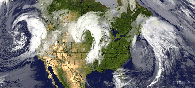
Scattered precipitation, cold temperatures, and north/northwest winds compose today's conditions. With the low pressure migrating towards Wisconsin, it wasn't too difficult to predict that the winds would start to shift to a northern origin. By the time of this prediction the low pressure zone has moved directly over central Wisconsin, causing gentle north winds from across Lake Superior. The radar still shows a number of precipitation bands moving in from the west, which makes afternoon or evening rain a strong possibility. Taking a look at other regions, the west coast is entirely dry, while the east coast is being pummeled by the left overs of the midlatitude cyclone earlier this week. New England is almost completely blanketed with precipitation and a dry line is moving storms over Florida.
Today's Haiku
Rain finally stopped,
But it should restart later
What a gloomy week
Today's Conditions
Temperature: 40 degrees Fahrenheit
Dew point: 37 degrees Fahrenheit
Wind: 10mph NE
Cloud cover: Overcast and raining
Pressure: 1003.0 mb
As I predicted, the rain has continued through the night and has yet to stop today. Temperatures and pressure levels have hardly changed since yesterday's update, and once again the conditions are likely to carry over into tomorrow with the chance of snow if the temperatures allow it. The low pressure system controlling the cyclone has shifted to the southeast of its original position, which has caused local winds to shift more towards the north than yesterday's strong east winds. The strong mid-latitude cyclone from yesterday has lost some of its strength, as the precipitation bands have begun to migrate away from the low pressure center. My prediction for tomorrow includes precipitation, colder temperatures, and winds shifting towards the northwest.
Today's Haiku
It's still raining here
Good thing it's not snowing yet
Hopefully it won't
Today's ConditionsTemperature: 45 degrees Fahrenheit
Dew point: 36 degrees FahrenheitWind: 26mph ECloud cover: Overcast and rainingPressure: 1006.0 mb
Rain, rain, and more rain. Strong winds from the east are telltale signs of low pressure to the
southwest and inclement weather. "When the wind is in the east, 'Tis neither good for man nor beast." The low pressure system causing this mess is centered over Nebraska and is orchestrating the wind patterns for the entire country, pulling winds up from the gulf, down from Canada, and across the Great Lakes, along with drawing in from the high pressure systems on the east and west coasts. A large band of precipitation is currently covering Wisconsin, Minnesota and much of the Dakotas. Strong east winds will try their best to keep this storm stationary, and I predict it will definitely stick around for the next few days.
Today's Haiku
Rain, rain, go away
Come again some other day
I'm serious though
Today's ConditionsTemperature: 54 degrees Fahrenheit
Dew point: 21 degrees FahrenheitWind: 8mph NCloud cover: FairPressure: 1017.7 mb
As I predicted, clear skies and warm weather made their way to Eau Claire today, obvious signs of nearby high pressure. Winds from the north tell me that the high pressure system is located to the north and slightly to the west of Eau Claire, causing the outward spiral of wind to head directly south towards Eau Claire. A wall of low pressure to the west should travel to our region by tomorrow, causing precipitation and a possible drop in temperature. My prediction for tomorrow includes mid 40 temperatures and afternoon showers.
Today's Haiku
Beautiful day here
Mid 50's and lots of sun
Will rain tomorrow
Today's ConditionsTemperature: 68 degrees Fahrenheit
Dew point: 52 degrees FahrenheitWind: 22mph WCloud cover: FairPressure: 1011.7 mb
Following a warm and humid weekend, roads showed signs of over night rain as temperatures reached the 60's as early as 8am. Moderate winds from the west mean there must be a high pressure system to our west and a low pressure system to our north. A large cold front is just now passing the Mississippi River, and should cause for a decent drop in temperature tonight. Predictions for the near future include clear skies and warm temperatures, we should do well to avoid any rain in the next few days.
Today's Haiku
Today it is warm
Warm enough to put on shorts
And wear a t-shirt
Today's ConditionsTemperature: 35 degrees Fahrenheit
Dew point: 33 degrees FahrenheitWind: 10mph NWCloud cover: OvercastPressure: 1021.1 mb
Gloomy skies are a common theme this week, bundled with chilly temperatures and scattered precipitation. Precipitation from this morning has moved east over Lake Michigan at this point in the day. Very cold and humid air is due to winds rushing down the east coast before turning inward towards the center of the country. The winds are swerving around the cold front to land in a low pressure system directly over Wisconsin, churning with the frigid temperatures from Canada. Scattered precipitation is moving over the Dakotas with small chances of reaching Eau Claire, while a much larger system is blanketing Oregon and Washington. Predictions for the near future include similar temperatures with slightly less cloud cover into tomorrow.
Today's Haiku
Rainy morning sky
Warm and cold fronts passing through
The same tomorrow
Today's Conditions
Temperature: 24 degrees Fahrenheit
Dew point: 15 degrees Fahrenheit
Wind: 7mph NW
Cloud cover: Mostly cloudy
Pressure: 1021.1 mb
As I predicted, cool temperatures and less cloudy skies occupy the atmosphere in Eau Claire. High pressure in the central regions of our country are causing for clear and dry conditions while the coasts tell a different story. Warm and moist tropical air masses are mixing with the strong cold front and low pressures to create an enormous band of severe weather down the east coast. Water vapor from the Atlantic is being funneled straight into the storm, fueling it with precipitation during the frontal lifting process. Small amounts of precipitation over Washington could find their way over northern Wisconsin, making a chance of rain in the near future not unreasonable.
Today's Haiku
Cold front and moist air
Plus warm, moist air mass off coast
Fuels the perfect storm
Today's ConditionsTemperature: 30 degrees Fahrenheit
Dew point: 18 degrees FahrenheitWind: 21mph NCloud cover: OvercastPressure: 1015.0 mb
The thunderstorms I predicted did not arrive but instead left gentle rains overnight on Friday. Gloomy weather stayed consistent on Saturday and eventually snowed late Sunday night. This morning we are left with freezing temperatures, overcast skies and snow covered ground. Strong winds from the north tells me that a cold front from the north has passed through and that there must be a low pressure system to our east. Upon looking at the surface map, my observations stand true considering the long arcing cold front from Michigan to Colorado and the low pressure trough located over the Great Lakes. Scattered precipitation moving our way will likely cause for partly cloudy skies until tomorrow, and no more fronts in the near future should yield similar temperatures as well.
Today's Haiku
Can't believe it snowed
We all thought it was over
Worst Monday ever
Today's ConditionsTemperature: 44 degrees Fahrenheit
Dew point: 30 degrees FahrenheitWind: 5mph SWCloud cover: OvercastPressure: 1015.6 mb
The clouds rolled in last night as I predicted, leaving us with on and off showers and dark skies this morning. A small high pressure dome to our immediate west is causing for gentle winds from the southwest as scattered precipitation makes its way across the state. A cold front crossing the U.S. Canada border will eventually pass to drop temperatures once they finally warm up today. Many scattered pressure systems and colliding fronts may cause this year's first thunderstorms sometime tonight or into tomorrow. Predictions for the near future include gentle winds and overcast skies before clearing up this afternoon, leading into unstable weather overnight.
Today's Haiku
Dark and wet morning
My favorite kind of weather
Storms likely tonight!
Today's Conditions
Temperature: 51 degrees Fahrenheit
Dew point: 30 degrees Fahrenheit
Wind: 13mph W
Cloud cover: Fair
Pressure: 1006.2 mb
Temperatures this morning were steady within the mid 40's due to the early cold front but are expected to rise up to the lower 60's midday. The cold front is clearly visible from the wind map, as warm moist air from the gulf is being dragged up and sent all the way to the Great Lakes to drop the precipitation. The precipitation that moved through this morning was the last of the day, as only small scattered systems remain out west. It is safe to say that the remainder of today will be clear and sunny with a chance of some clouds leading into tomorrow morning.
Today's Haiku
Cold front just passed through
Another beautiful day
Get outside you fools!
Today's ConditionsTemperature: 49 degrees Fahrenheit
Dew point: 43 degrees FahrenheitWind: NoneCloud cover: OvercastPressure: 1008.8 mb
Surely spring will finally begin today. Temperatures are currently reaching into the 50's and are expected to just miss the 60's by a small margin. Overcast skies are keeping it dark but are doing a great job at trapping in the heat and no wind certainly helps to keep the temperatures up as well. Low pressure all around Wisconsin is causing for winds to avoid the state for the most part, with the exception of a few stray gusts coming across Lake Michigan. Scattered precipitation moving across the Midwest may choose to drop its contents at some point today, and if that should happen, the rain won't last for too long. Predictions for the near future include similar temperatures tomorrow with clearer skies after the clouds and precipitation move on today.
Today's Haiku
Chance of rain today
It feels too warm to be real
Go away winter


.gif)


